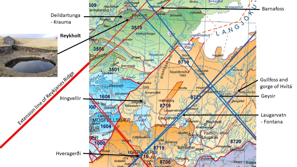
Extending the Reykjanes Ridge mathematically, it does cross the most powerful low temperature geothermal area of Iceland of Reykholtsdalur. A division line is found under the farm Reykholt.
The position of Reykholt and some other scenic areas.
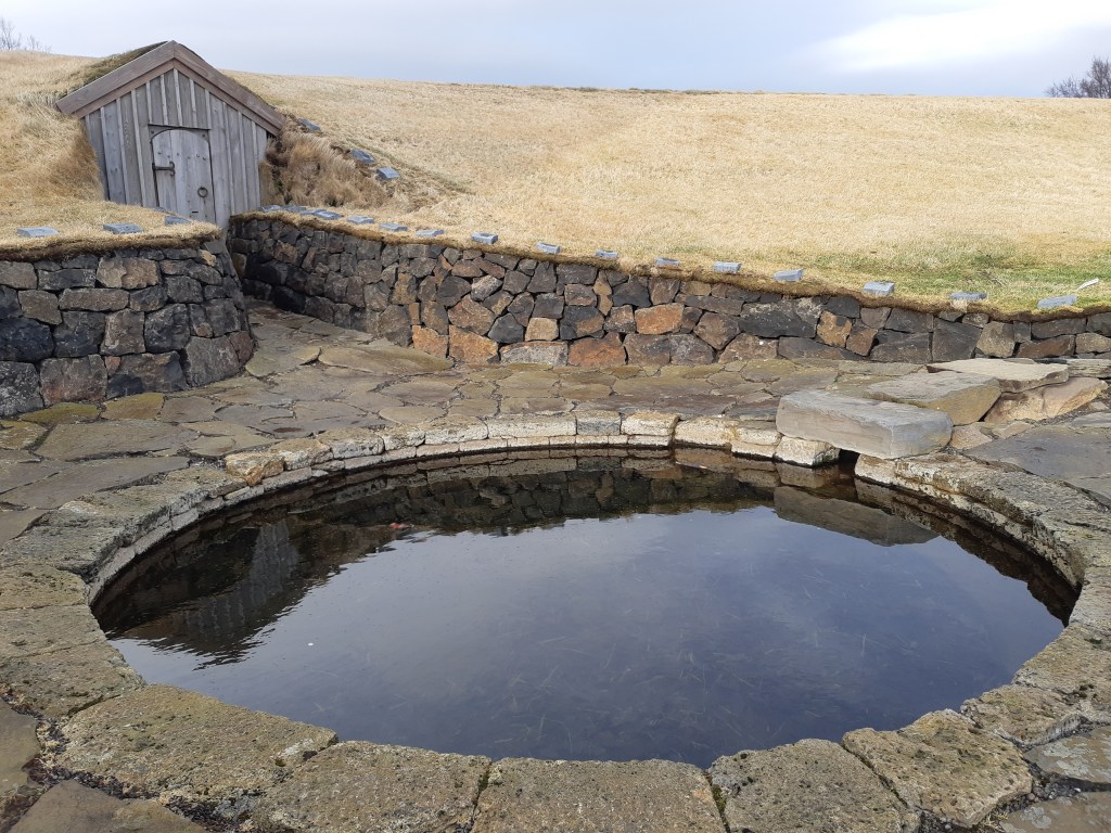
The pool at Reykholt is quite famous. Snorri Sturluson, the most famous writer of Iceland, lived there in the 13th century.
Snorralaug
The hot water flows into the pool Snorralaug, translated as Snorri’s Pool, from the hotspring Skrifla.
Skrifla
The system was quite advanced, because steam was led from this hotspring through a pipeline into Snorri’s farm, heating the floor inside it.
Snorri Sturluson was the richest and most powerful man in Iceland, and did choose a fabulous place as his home.
Japan is known for volcanoes and hot springs, and having a critical position between different tectonic plates. The conditions within the mantle should add to that story. Division between large convection rolls is expected to be located under Japan, affecting the smaller convection rolls of the asthenosphere.
One convection roll is highlighted here with red, because a large number of volcanoes happens to be located within that area. This volcanic roll, swaying towards NE, is found at the depth of around 120-265 kilometers. The rolls underneath, swaying towards NW, are at the depth of 265-410 km. Below 410 km, the large convection rolls of lower mantle are found. As the large scale lower mantle division line is found under the highlighted roll of the asthenosphere, the importance of that roll becomes more understandable. To fully understand the geology of Japan, both the tectonic drift of the converging plates and the relevant mantle currents have to be considered, to see how these factors interact with each other.
Note the location of Fuji, is directly above the division lines of two layers (and the division line of the lower mantle as well).
Many have noticed that the continents look somewhat similar, but it is difficult to say what. The northern part tends to be wider than the southern part. Comparing with the divisions found within the convection rolls model, a basic shape of North America be pointed out.
Basic Shape of North America.
The coast of the Pacific Ocean is obviously more regular than the East Coast. The continent all the same follows this basic shape surprisingly well. This shape resembles the southern part of Africa as shown in another post.
The most apparent geothermal areas in Greenland are found around Scoresbysund. Considering the second layer of convection rolls, the areas in Greenland are found as a continuation of the volcanically and geothermally active zones of Iceland. No one expects underlying connection in that direction, because the upper most convection rolls mark the main trend of tectonic alignment in Iceland. In this way, the exceptional activity level in Iceland makes itself felt in Greenland too.
Convection rolls connecting active areas in Iceland and Greenland.
The numbered convection rolls are leading to: 1) West Volcanic Zone, 2) Mid Iceland Belt, 3) East Volcanic Zone, 4) North Volcanic Zone.
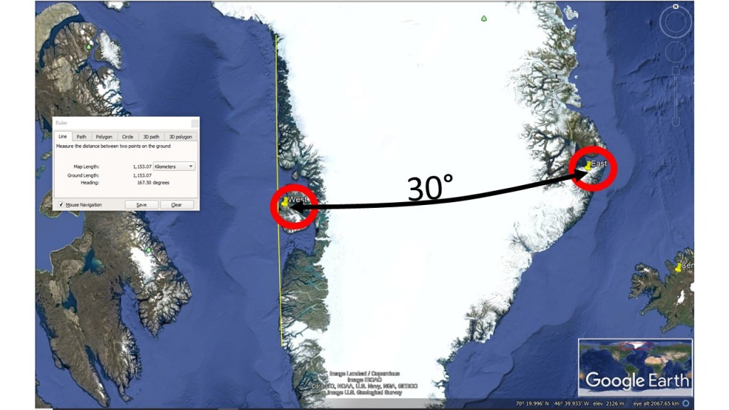
The geothemal areas at Disko are subject to similar effect, being exactly 30° farther to the west. The area is much older, and the main division line there is weaker, as the rifting process of Baffin Bay ceased a long time ago, which is explained here: https://en.wikipedia.org/wiki/Canadian_Arctic_Rift_System.
Basalt is mainly found in two areas of Greenland, in the western and eastern parts. These are found at similar latitude, and 30° apart. The convection rolls of lower mantle span 30° from east to west, so this leads attention to the history of tectonic events in the geological history of Greenland.
Basalt areas in Greenland found 30° apart at the same latitude of around 70°N.
The separation from Baffinland and the Jan Mayen Ridge occurred due to the effect of two different hubs of convection rolls division lines (division lines of different layers coincide there). This occurred a long time ago, so these areas have drifted away from those hubs. One is now near Nuuk and the other under Iceland.
To understand the background of this, we have to keep in mind that the Baffin Bay was formed first and the northernmost part of the Atlantic second. Let us have a look at the position of Greenland 60 million years ago when the Baffin Bay was forming:
The interplay of formation of Baffin Bay and N-Atlantic Ocean
Because of this, most geoloscientists think that a ‘hot spot’ did travel from W-Greenland to E-Greenland and from there to Iceland. The actual story, according to the convection rolls model, is different. First, a division line of lower mantle opened up the Baffin Bay, resulting in eastwards drift of Greenland. Then the other main division line, 30° farter to the east, where Iceland is now located, became more active. The N-Atlantic started to form with the development of the Ægir Ridge. Greenland started drifting along the track which has been measured accurately with GPS technology. https://www.lmi.is/static/files/utgefid_efni/Maelingar/isnet_endurmael_2016_skyrsla.pdf . According to the drift vectors in that report, Scoresbysund of Greenland has been drifting to the NW from the volcanically active center of Iceland for about 40 million years, as stated in this paper: https://www.geothermal-energy.org/pdf/IGAstandard/WGC/2010/0158.pdf. Therefore, the geoscientis seem to be a bit mistaken, counting these two ‘hot spots’ as one, and secondly, is has to be noticed that convection rolls division lines carry heat to these areas still today, and should not be thought of as ‘hot spot tracks’, as that is misleading.