I am a geologist, graduated from the University of Iceland, and taught geology for a few years. I have gained some knowledge about Earth's inner structure, so I provide this website as my contribution to answer one of the greatest questions remaining within the realm of geoscience. Experiments show that the mantle should form convection rolls when close to the melting point. I took this literally, and calculated the dimensions and shape of these mantle convection rolls. Then I compare that model with the surface. This makes it possible to provide many interesting examples about geology found on my blog.
The two scenic spots of Þríhnúkagígur and Leitin are found near Reykjavík. The former is a crater with an empty magma chamber underneath. Now it is possible to enter the resulting cave, one of its kind in the world. The second is a crater very few people visit, but the lava from it created the Raufarhólshellir lava tube, known as the Lava Tunnel in tourism. It also created Rauðhólar pseudocraters and Tröllabörn hornitos in the same eruption, over 5000 years ago. Both craters are found along the mysterious 64th parallel.
Comparing convection rolls and real time events is one aspect of looking into the details of the magma currents. Earthquakes along the line extending from the Reykjanes Ridge follow very similar pattern. The earthquakes occur on lines crossing the RR extension line. The green stars show earthquakes over 3 on Richter scale.
Earthquakes compared with convection rolls division lines.
The volcanic zones of Iceland are quite distinct and well defined. The forces shaping them can also be defined, and here a few points regarding the mantle flow underneath are pointed out. The convection rolls division lines grid is drawn on a map base from Landmælingar (The National Land Survey of Iceland) with the tectonic drift vectors from 1993 to 2004 marked with blue arrows. Comparing these vectors with the polygons (and the effect of local up-welling and down-welling) indicates the resulting stress field.
A few points about Volcanic Zones and Systems in Iceland
1. The line between the convection rolls shaping the Reykjanes Ridge is here partly responsible for the formation of Krafla and Þeystareykir volcanic sites. The rolls are subducted by the polar rolls, but still make their presence felt, opposing western drift. Like most central volcanoes of the North Volcanic Zone, they are found west of the NS axis of the zone.
2. The up-welling polar convection roll of 120 km depth locally opposes the general drift to the west. This leads to the formation of Fremri Námar Volcanic Site.
3. In this area the two division lines of the upper most convection rolls and the 3rd layer almost coincide with each other, forming the Tungnafellsjökull Site.
5. Öræfajökull is maily a result of the fact that all four upper layers division lines coincide at a single point, in the same way as Hekla. But the volcanic zone extending from Öræfajökull to Snæfell is a result of spreading to the east, with geothermal heat also appearing at the edge of Vatnajökull from the two up-welling lines of convection layers 1 (upper-most) and 3.
6. The clear-cut edge of the East Volcanic Zone must be there for a reason. The reason is that the upper-most convection rolls down-welling division line is found there! The third layer coincedes with the upper-most one, exaggerating the effect, and has even a ruling effect as seen at the Kverkfjöll Volcanic System. Laki is found near the point, and therefor the Laki eruption seems to have been due to the effect of both Grímsvötn, providing the main flow of magma, and some effect of the NW-SE oriented upwelling line underneath Laki.
7. At these crossings of lines, the EVZ suddenly trends southwards. This is opposing the general NE-SW ´rule´, but it obviously coincides with the polygon east of the Westman Islands.
8. The Westman Islands Volcanic System is marked by a single polygon, actually the north-western half of it. Together with Eyjafjallajökull and Tindfjöll it is a part of the South Volcanic Belt, So it is regarded as separated from the East Volcanic Zone in a way. The main reason is that no rifting takes place there, as the eastwards drift actually takes place away from the Reykjanes Ridge south of the N-American/Eurasian division line (shown as thin black line).
9. In a way, Hveragerði is the most central place, because the large lower mantle convection rolls division line is found there underneath. The large scale division line is left a bit unattended, though, because the immediate effect of the small upper convection rolls is found more clearly, and the fact that the division between a pair of the upper most convection rolls follows the same path as the division line between the large scale rolls underneath. It is also confusing, that the large scale rolls division line under Iceland is up-welling, but the upper-most small scale rolls over them are down-welling.
10. This point marks the beginning of Icelandic geology, the turning point from Reykjanes Ridge to the Oblique Rift Zone of Reykjanes Peninsula.
11. The eastern edge of West Volcanic Zone is marked by down-welling division lines, in the same way as the East Volcanic Zone at the same latitudes.
12. These up-welling lines both oppose the general drift to the west, and provide direct stress on the area. At this latitude, the general tectonic trend changes.
13. The Ljósufjöll Volcanic System extends between two polygons, ending at the up-welling division line.
14. The other end of Ljósufjöll is found at down-welling division line.
15. The West Volcanic Zone starts to trend NS at this latitude, ending at a up-welling division line.
16. The Mid Iceland Volcanic Zone mainly takes up one polygon. Two volcanic systems, of Hofsjökull and Kerlingarfjöll, are found connected with different division lines. The local stress zone is actually following the main trend, but local deviation to the NE and general tension at this latitude, in between large and regular polygons south of the area and small, rather irregular polygons north of it, lead to a formation of a rather small volcanic zone. Actually, every main polygon along the 65th parallel has volcanic sites, from Snæfellsjökull in the West to Snæfell in the East.
Comparing Iceland and Norway at the same latitudes 30° apart should lead to some analogy due to the same pattern of convection rolls. Here is an example.
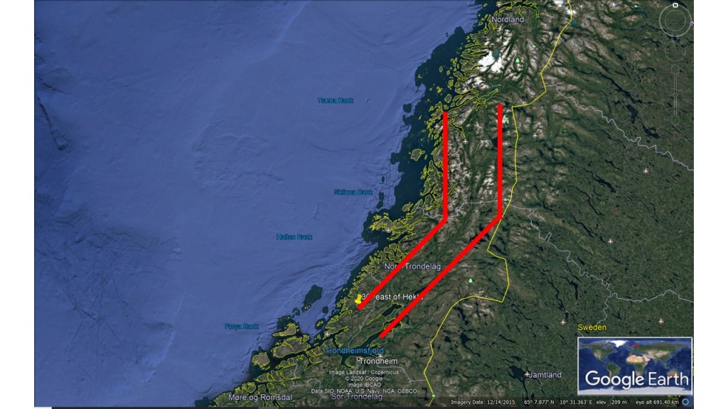
East and North Volcanic Zones of IcelandMap of Norway with markings 30° east of the East and North Volcanic Zones of Iceland
The similarity is quite striking. A NS-structure is found accurately 30° east of the North Volcanic Zone of Iceland, which is aligned exactly NS. The bending structure connecting with the NE-SW oriented East Volcanic Zone of Iceland is found exactly at the same latitude in Norway. In addition, the points 30° apart, of Hekla in Iceland and in the Trondheim area in Norway, are aligned exactly in the same way.
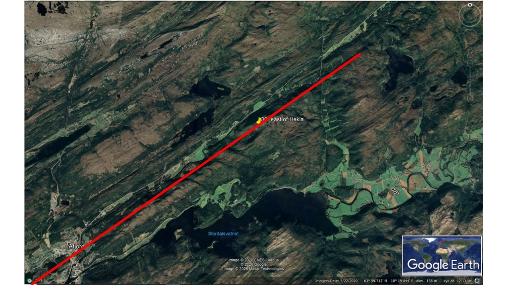
The consistence between Hekla and its counterpart exactly 30° to the east is hard to explain. Hekla is on the 64th parallel, 19°40’W. 30° farther to the east on the 64th parallel, namely 10° 20’E, the landscape is oriented exactly the same way as Hekla. The volcano Hekla is a bit special, located in between the Eastern Rift Zone and the South Iceland Volcanic Belt. Therefore it is not pulled apart with the rift zone perpendicular to the convection rolls. The sideways drift of the tectonic plates therefore influences its alignment. It can be calculated as: A=(C+C/2)/2, where C stands for Convection orientation, and A is the allignment direction, in this case W35°N.
Hekla.Norway 30° to the East of Hekla.
In Norway, there is no rift zone, but similar pressure vectors can occur, as the polygon pattern within the durctile part of the tectonic plates is exactly the same at these locations. That explains identical orientation of the topography.