Many of the famous volcanic and geothermal areas in Iceland are distributed in a very regular pattern:
When we trace three specific latitudinal bands across Iceland, a striking regularity emerges in the distribution of volcanic and geothermal areas. These zones appear to align with key boundaries in Iceland’s underlying mantle-convection structure.
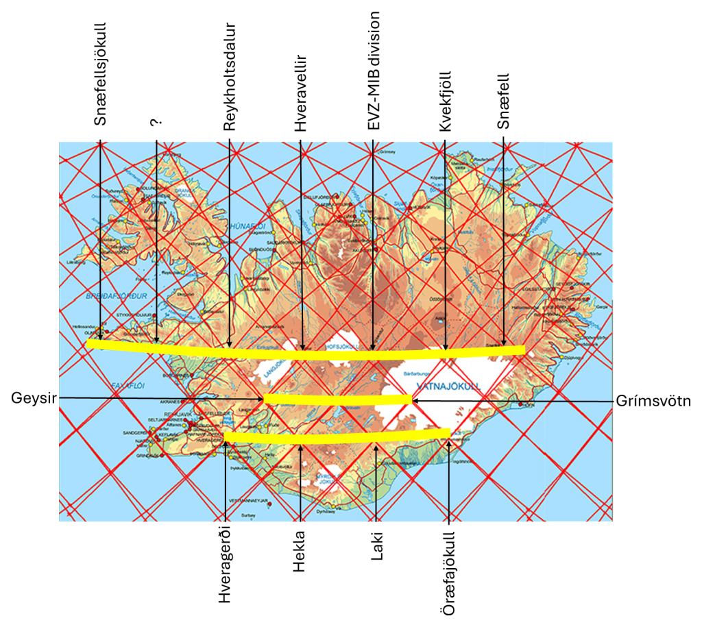
1. The ~64°48′N Parallel
Along approximately 64°48′N, several well-known volcanic and geothermal sites fall in a remarkably linear arrangement. Snæfellsjökull (64°48′32″N) lies on this line, and further east we encounter Reykholtsdalur, Hveravellir, the East Volcanic zone – Mid Volcanic Belt (EVZ–MVB) division point, Kverkfjöll, and Snæfell. The fact that such major and geographically separated systems cluster around the same latitude suggests that their positions are not random; they coincide with an underlying structural feature in the mantle.
2. The ~64°19′N Parallel
Geysir is located at 64°18′49″N, and 3° of longitude to the east lies Grímsvötn, one of Iceland’s most active volcanic centers. This west–east correspondence hints that these two sites sit along the same deep-seated mantle boundary, where material upwelling or shear occurs as adjacent convection rolls interact.
3. The ~64°00′N Parallel
A third set of volcanic features—Hveragerði, Hekla, Laki, and Öræfajökull—also display a regular spacing. Each lies approximately 1.5° apart along the 64th parallel. These evenly spaced intervals are consistent with boundary intersections between mantle convection rolls. cells.
How These Parallels Fit Together
When plotted on a map, these three latitudinal bands exhibit a coherent geometric relationship. Rather than being isolated curiosities, they form a patterned framework that mirrors the predicted arrangement of convection rolls of the upper mantle. In the model, Iceland sits above the junction of several long, ribbon-like convection structures that rise and sink in a repeating pattern. Where roll boundaries intersect, and special structures or divisions are found on the surface, it can be regarded as a theoretical explanation of the relevant geological circumstances.
The Icelandic data align with this idea:
- Volcanoes and geothermal fields cluster where convection-roll boundaries intersect.
- Spacing is regular, matching the predicted periodicity of mantle-flow structures.
- Parallel latitudinal bands correspond to horizontal divisions between roll layers, while the longitudes match the vertical shear boundaries between adjacent rolls.
Broader Significance
These Icelandic examples support the broader global pattern: volcanic, seismic, and geothermal activity frequently coincides with the geometry of the Earth’s internal convection structure. Iceland—sitting atop a spreading ridge and a major upwelling—is particularly sensitive to the arrangement of these convection rolls, making it an ideal natural laboratory. The observed regularities reinforce the hypothesis that the distribution of volcanic centers is controlled not only by shallow crustal processes or isolated mantle plumes but also by the deeper, long-wavelength organization of mantle flow.
On the map, a question mark has been added, namely at the Snæfellsnes Peninsula, where one spot seems to be missing within an otherwise regular row of active sites. What does that mean?
