This figure presents the results of ISNET geodetic measurements from the ISN93 and ISN2004 campaigns.
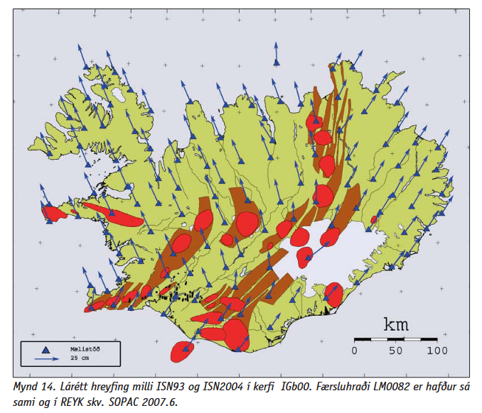
The data clearly indicate that the overall horizontal plate motion across Iceland is directed predominantly towards the north. Furthermore, the velocity field demonstrates that the plate motion in northern Iceland is approximately symmetric with respect to the north–south axis: motion vectors on the Westfjords are oriented toward the northwest, whereas those on the Eastfjords are oriented toward the northeast. The vectors on both sides of the island form nearly identical angles relative to geographic north.
The figure is based on the original measurement data and therefore represents the true directions of crustal motion. The displacement rates were derived using the SOPAC velocity field at epoch 2007.6, under the assumption that the motion at station REYK is equivalent to that observed at LM0082. Consequently, the figure provides a realistic depiction of the current kinematic framework of Iceland.
The magnitude of the plate motion is notably greater than commonly assumed. On the western part of Iceland, the motion typically reaches close to 2.5 cm/yr towards the northwest and the northeast, as shown (see arrow at lower left corner on the map, showing the length of 25 cm in 10 years). On the other hand, the spreading rate between the North American and Eurasian plates—i.e., the rate of divergence across the rift zones—is approximately 2 cm/yr. It is important to distinguish between absolute plate motion and spreading rate: while the total drift relative to a stable reference frame is on the order of 2.5 cm/yr on each side, the divergence between the two plates amounts to roughly half that value. Many descriptions of Icelandic tectonics cite about 1 cm/yr of motion to the west and 1 cm/yr to the east; however, these represent the half-spreading rates rather than the absolute plate velocities observed in geodetic measurements.

The two different drift trends at the eastern and western sides of Iceland can also be seen on this map from Wikipedia.
Geodetic networks such as ISNET have been instrumental in quantifying this relative motion and in delineating the internal deformation of the island. The observed symmetry in motion across northern Iceland reflects the geometry of the ridge system, with extension distributed among several rift zones and connected by major transform fault systems, including the South Iceland Seismic Zone and the Tjörnes Fracture Zone. These results are consistent with the regional plate-tectonic model and provide refined constraints on the present-day strain field within the Icelandic plate boundary zone.
